Fujitsu to
Exhibit at “ITS World Conference 2016” in Melbourne
Spotlighting latest technologies in Human Centric Innovation to
create comfortable communities
TOKYO, Sept 28, 2016 – (JCN Newswire) – Fujitsu
Limited and Fujitsu Ten Limited (collectively “Fujitsu”) today
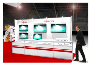
announced their joint exhibit at ITS World Conference 2016, from October 10-14in Melbourne, Australia.
Under the theme “Human Centric Innovation –
Driving Liveable Society,” Fujitsu will exhibit the Group’s efforts in ICT
solutions for automobile transportation, combining technologies such as the
Mobility IoT Platform, which provides a variety of mobility-related services;
Fujitsu Intelligent Society Solution SPATIOWL, a cloud service for working with
location data; a drive recorder that collects information on vehicles, driving
conditions, and drivers; and human-sensing technology to detect drowsy drivers.
About the Exhibit
Dates: October 10-14, 2016
Place: Fujitsu Corner, Booth 709, Japan Pavilion
Theme: Human Centric Innovation – Driving Liveable
Society
Description:
1. Services that use the Mobility IoT Platform to
help make driving safer
This part of the exhibit introduces services based
on the Mobility IoT Platform, which enables the provision of a wide range of
services, using mobility-related big data, such as on cars, and map data.
– Services that use the Mobility IoT Platform and
manage and distribute Dynamic Maps
These services integrate the Dynamic Map Platform
and Linked Open Data(1), along with changes to road conditions provided by
various sensor information, and manage and quickly process them on the Mobility
IoT Platform, providing updated Dynamic Map data to vehicles as a timely
service.
– Services using AI to help make driving safer
These services use Fujitsu’s AI “Zinrai”
technology to combine detectable traffic conditions surrounding the car, by
recognizing other vehicles and pedestrians in images of the car’s surroundings,
and sensor data on the driver, such as eye blinks, with dynamic map information
for analysis, to encourage safer driving habits.
2. Services that use SPATIOWL cloud services for
location information
This part of the exhibit shows how Fujitsu uses
SPATIOWL for real-time positional information.
– Visualizing and analyzing operating conditions
for public-transit authorities
SPATIOWL performs multifaceted analyses of
public-transit operations according to time (months, days, days of week, hours,
and so forth), as well as location. Results are plotted on a map to make them
more comprehensible, showing when and where delays have occurred, and how
severe they are, to give a more intuitive grasp of trouble spots.
And a driver drowsiness detector helps make
long-haul driving safer by spotting trends in driver drowsiness based on pulse
rates.
– Traffic-congestion detection using image
analysis
Image analysis from CCTV cameras installed along
roads can be used to detect traffic congestion, accidents, and violations in
real time, and by connecting to SPATIOWL, that information can be used to
instantly produce an incident map covering a broad area.
3. Services using data from drive recorders
– G500 Series communications-type drive recorder
Gathering and analyzing a variety of car data
through cloud connectivity with communications functions, the recorder assists
customers’ safe driving and more efficient management of vehicle operations.
This exhibit showcases the system’s ability to capture recorded images using
its remote operations feature when there is an accident, and its safe-driving
educational tools that automatically extract video of the situation when the
driver swerved or suddenly applied the brakes.
– Advanced drive-recorder concept
This exhibit shows how Fujitsu technology can use
drive-recorder data stored in the cloud along with image-recognition and
AI/deep-learning technologies to perform sophisticated analyses, with advanced
services that encompass not only driver behavior but also extensive stored data
and ICT capabilities, including pedestrian and bicycle information over
numerous locations and timeframes, and even locations, times, and weather
conditions under which wild animals are likely to dart into the road.
(1) Linked Open Data
Public datasets in a linked data format.
For the LATEST tech updates,
FOLLOW us on our Twitter
LIKE us on our FaceBook
SUBSCRIBE to us on our YouTube Channel!


