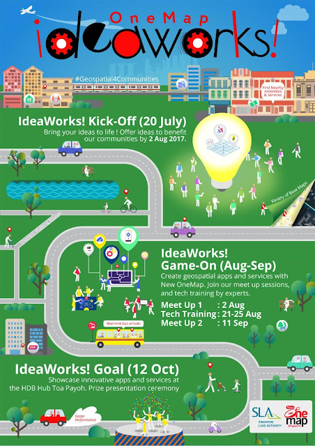
Singapore, 20 July 2017 – The
Singapore Land Authority (SLA) has today announced the launch of “OneMap IdeaWorks!”. Bringing
together technologists, data scientists and community organisations, the
three-month campaign aims to foster co-development of geospatial solutions and
analytics through the use of the new OneMap and open geospatial data, in
support of the Smart Nation initiative.
2
“OneMap
IdeaWorks! will build and strengthen the collaboration among different
communities through the use of geospatial information science and technology,”
says Mr Ng Siau Yong, Director of GeoSpatial and Data Division, SLA.
“OneMap
IdeaWorks! will build and strengthen the collaboration among different
communities through the use of geospatial information science and technology,”
says Mr Ng Siau Yong, Director of GeoSpatial and Data Division, SLA.
“We invite community
organisations to share their challenges; the technology communities will put
their innovative minds together to help tackle the challenges by making use of
the new OneMap and open geospatial data.” Challenges could come from any or all
of these areas: Community, social services, environment, health, transport and
heritage.
3
SLA has engaged
several community organisations, such as Kwong Wai Shiu Hospital and Singapore
National Stroke Association, who have contributed challenge statements and hope
to get ideas and solutions from the technology community. Mr Ng Herk Low,
Assistant Chief Executive, SG Enable, an agency dedicated to enabling persons
with disabilities, says, “Information and technology play an important role in
enabling persons with disabilities to lead independent lives. Through OneMap
IdeaWorks!, we hope to see information on accessibility being readily provided
to persons with disabilities and their caregivers, helping them to overcome
challenges in navigation and route planning.”
4
Start-up groups
and tertiary institutions such as NUS Enterprise, Nanyang Polytechnic and SMU
Living Analytics Research Centre (LARC) have pledged their support to gather
their students, technologists and data scientists to participate in the
development of apps, solutions and analytics. Ms Jeanne Liew, Principal &
CEO of Nanyang Polytechnic, says, “The long-standing relationship between NYP
and SLA has seen the fruitful development of excellent geospatial capabilities.
We are honoured that our students and lecturers are working on, and lending
expertise to, such a national-scale project. This new OneMap IdeaWorks! project
is set to yield excellent data and applications that can improve our lives,
plus give communities the tools to connect better.”
5
To date, SLA has
garnered 60 challenge statements from 19 community and public agency partners.
Seven technology and content partners have pledged their support for OneMap
IdeaWorks! Dr Chong Yoke Sin, Chief Enterprise Business
To date, SLA has
garnered 60 challenge statements from 19 community and public agency partners.
Seven technology and content partners have pledged their support for OneMap
IdeaWorks! Dr Chong Yoke Sin, Chief Enterprise Business
Group of
StarHub Ltd, says, “StarHub is pleased to support the SLA as the key analytics
partner for its OneMap Ideaworks! event. As a home grown company and leading
telco data analytics provider, we are excited to help the local developers
leverage analytics to build better apps and services for the benefit of the
people and communities in Singapore.” “We are very encouraged by the good
response and strong support,” added SLA’s Mr Ng, “it goes to show that our
technologists and analysts are keen to put their skills and expertise to help
the communities.”
6
OneMap IdeaWorks!
will conclude on 12 October 2017 with a showcase of apps, solutions and
analytics that solve the challenges of the community organisations. From now to
then, OneMap IdeaWorks! partners will use the new OneMap Application
Programming Interface (API) services, some 300 sets of open geospatial data and
data provided by the content partners, and data from their own sources to
develop apps, solutions and analytics.
7
The new OneMap is
a mobile-centric platform offering location-based information and services for
use by everyone. It has been built by SLA’s geospatial engineers based on open
source technology as part of geospatial capacity building.
The new OneMap is
a mobile-centric platform offering location-based information and services for
use by everyone. It has been built by SLA’s geospatial engineers based on open
source technology as part of geospatial capacity building.
8
Community
organisations, technologists and data scientists are welcome to visit http://ideaworks.onemap.sg to post challenge statements or register
interest to develop solutions by 2 August 2017.
Community
organisations, technologists and data scientists are welcome to visit http://ideaworks.onemap.sg to post challenge statements or register
interest to develop solutions by 2 August 2017.
Fact Sheet – OneMap IdeaWorks!
About OneMap IdeaWorks!
1) OneMap IdeaWorks! is a three-month campaign comprising a series of
events as follows:
events as follows:
|
Date
|
Event
|
Activity
|
|
20 Jul 2017
|
IdeaWorks! Kick-off
|
Challenge statements contribution
|
|
Registration for technologists and data
scientists. |
||
|
02 Aug 2017
|
IdeaWorks! Meet up 1
|
Match making teams with challenge statements
|
|
21 Aug 2017
|
IdeaWorks! Tech
|
OneMap API, open source, geospatial training
|
|
Workshop
|
||
|
11 Sep 2017
|
IdeaWorks! Meet up 2
|
Solutions preview
|
|
28-29 Sep 2017
|
IdeaWorks! Judging
|
Show and tell, judging
|
|
12 Oct 2017
|
IdeaWorks! Goal
|
Showcase all entries, prize presentation
|
2) Contribution
of challenge statements is open now till 2 August 2017.
of challenge statements is open now till 2 August 2017.
3) Registration
of solution development is open now till 18 August 2017.
of solution development is open now till 18 August 2017.
4)
Visit http://ideaworks.onemap.sg to participate. Participants are also able to
interact and link up via the forum on the website.
Visit http://ideaworks.onemap.sg to participate. Participants are also able to
interact and link up via the forum on the website.
5) OneMap
IdeaWorks! Partners
IdeaWorks! Partners
|
a. Community Partners
|
·
|
Asian Women
Welfare Association (AWWA) |
|
|
·
|
Causes for
Animals |
||
|
· Kwong Wai Shiu Hospital
|
|||
|
·
|
Nature
Society |
||
|
· Pasir Ris-Punggol Grassroots
|
|||
|
·
|
Singapore Children’s
Society |
||
|
·
|
Singapore
Heart Foundation |
||
|
·
|
Singapore
Kindness Movement |
||
|
· Singapore National Stroke
Association |
|||
|
· Very Special Arts Singapore
Ltd |
|||
|
b. Agency Partners
|
·
|
Ministry of Social and Family Development
|
|
|
·
|
Ministry of
Education |
||
|
·
|
Ministry of
Law |
||
|
· National Council of Social
Service |
|||
|
·
|
National
Heritage Board |
||
|
·
|
SG Enable
|
||
|
· Infocomm Media Development
Authority |
|||
|
·
|
Land
Transport Authority |
||
|
c. Technology &
|
·
|
NUS Enterprise
|
|
|
Analytics Partners
|
·
|
Nanyang
Polytechnic |
|
|
· SMU Living Analytics Research Centre (LARC)
|
|||
|
d. Content Partners
|
·
|
Starhub Ltd
|
Anonymised analytics
|
www.starhub.com
|
|
data
|
||||
|
·
|
Planet Labs
|
Satellite Imagery
|
www.planet.com
|
|
|
·
|
Esri
|
Geospatial training
|
esrisingapore.com.sg
|
|
|
Singapore
|
||||
|
·
|
GeoIcon
|
Open source training
|
www.geoicon.com
|
|
|
·
|
LotaData
|
Location based events
|
lotadata.com
|
|
|
and businesses
|
||||
|
·
|
Mapillary
|
Street view photos
|
www.mapillary.com
|
|
|
·
|
Spacetime
|
Geospatial training
|
www.spacetime-
|
|
|
Technology
|
tech.com
|
|||
6) In addition to the content provided by the
Content Partners, some 300 sets of open geospatial data will be provided for
use in OneMap IdeaWorks!, These are broadly categorised into:
Content Partners, some 300 sets of open geospatial data will be provided for
use in OneMap IdeaWorks!, These are broadly categorised into:
a. Application
Programming Interface (API) such as routing and base maps
Programming Interface (API) such as routing and base maps
b. Data
layers such as eldercare, childcare services and healthier eateries.
layers such as eldercare, childcare services and healthier eateries.
7)
Solutions can be developed in the form of
mobile, web or analytics applications. The evaluation criteria include
originality (30%), social impact (40%) and sustainability (30%).
Solutions can be developed in the form of
mobile, web or analytics applications. The evaluation criteria include
originality (30%), social impact (40%) and sustainability (30%).
8)
OneMap IdeaWorks! has two main tracks – the
Open Category is open to the public, technologists and data scientists of all
ages. The School Category is open to students ranging from secondary up to
undergraduate levels. Prizes totaling more than S$10,000 will be awarded to the
winning teams.
OneMap IdeaWorks! has two main tracks – the
Open Category is open to the public, technologists and data scientists of all
ages. The School Category is open to students ranging from secondary up to
undergraduate levels. Prizes totaling more than S$10,000 will be awarded to the
winning teams.
About the New OneMap
1.
OneMap is an integrated public map platform
for government agencies to deliver location-based services and information. It
is a multi-agency collaboration with many government agencies currently
participating and contributing information. It is also used by the private
sector and the community to create useful and value-added services.
2. The
new OneMap is a brand new platform developed using Open Source Technologies by
an in-house team of developers in Singapore Land Authority, with new features
such as Map Styles, Driving and Journey Planner and BusRouteExplorer among
others. The current OneMap has been serving the public since 2010.
new OneMap is a brand new platform developed using Open Source Technologies by
an in-house team of developers in Singapore Land Authority, with new features
such as Map Styles, Driving and Journey Planner and BusRouteExplorer among
others. The current OneMap has been serving the public since 2010.
3.
The new OneMap provides the most detailed and
accurate national map of Singapore, with services and content customised to the
local context.
The new OneMap provides the most detailed and
accurate national map of Singapore, with services and content customised to the
local context.
4.
The mobile application, OneMap, is available
for download from the Apple App Store and Google Play Store.
The mobile application, OneMap, is available
for download from the Apple App Store and Google Play Store.
Features available in mobile app at Beta Launch:
a. Map
Styles – choose from four types of street maps to suit your preference
Styles – choose from four types of street maps to suit your preference
b.
Search – improved search engine which also
stores your previous five search locations
Search – improved search engine which also
stores your previous five search locations
c.
Driving and Journey Planner – get detailed
step by step driving and public transport directions, with walking directions
that provide the shortest, most sheltered and safe path
Driving and Journey Planner – get detailed
step by step driving and public transport directions, with walking directions
that provide the shortest, most sheltered and safe path
d.
Find Nearby – locate over 100 thematic
information, such as AXS Stations, Hawker Centres, Kindergartens and CHAS
Clinics within 2km of your current of specified location
Find Nearby – locate over 100 thematic
information, such as AXS Stations, Hawker Centres, Kindergartens and CHAS
Clinics within 2km of your current of specified location
e.
BusRouteExplorer – tap on any bus stop icon on
the map to display bus arrival timings and bus service routes
BusRouteExplorer – tap on any bus stop icon on
the map to display bus arrival timings and bus service routes
f.
TrafficQuery – view live traffic conditions,
traffic cameras and traffic incidents
TrafficQuery – view live traffic conditions,
traffic cameras and traffic incidents
g. LandQuery
– identify land ownership and land lot information
– identify land ownership and land lot information
6)
A set of Application Programming Interface
(API), such as base maps, address search, routing and reverse geocoding, is
also available at https://docs.onemap.sg for
technologists and data scientists to leverage on to create map-based
applications and services.
A set of Application Programming Interface
(API), such as base maps, address search, routing and reverse geocoding, is
also available at https://docs.onemap.sg for
technologists and data scientists to leverage on to create map-based
applications and services.
For the LATEST tech updates,
FOLLOW us on our Twitter
LIKE us on our FaceBook
SUBSCRIBE to us on our YouTube Channel!


